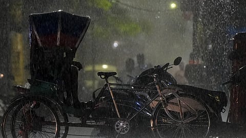
New Delhi | The monsoon kept people across India on their toes on Sunday, grounding flights, flooding roads and claiming one life in Mumbai, while Kerala was on high alert for floods and landslides, and Odisha and Himachal on the lookout for heavy rain.
The India Meteorological Department (IMD) said the well-marked low-pressure area over the Bay of Bengal intensified into a depression and is expected to cross the north Odisha coast within the next 24 hours, setting the stage for widespread heavy to very heavy rainfall across eastern India.
The financial capital took the hardest hit of the monsoon's fury as heavy overnight rain and gusty winds forced the suspension of runway operations at the Chhatrapati Shivaji Maharaj International Airport for an hour.
Four IndiGo flights were cancelled and 13 incoming flights were diverted before returning later. Flight tracking data showed around 90 per cent of departing flights were delayed by an average of more than an hour, while nearly half the arriving flights were also delayed.
The IMD retained a red alert after several areas received over 200 mm of rain, with some recording nearly 300 mm in 24 hours.
Heavy rain also led to waterlogging, traffic jams and tree falling incidents. A 63-year-old man died after a tree collapsed on a shop in Kurla, marking the second fatal tree-fall incident in Mumbai within a week.
The civic administration has declared a holiday for all government, private and civic-run schools and colleges in Mumbai on Monday in view of an 'orange alert' for heavy rain.
Odisha placed all districts on high alert, with the IMD issuing a red warning for heavy to very heavy rainfall in Sambalpur, Angul, Boudh, Sonepur and Kandhamal. Orange and yellow alerts were issued for the remaining districts.
Fishermen have been advised not to venture into the sea till July 7 because of rough to very rough conditions.
The neighbouring West Bengal is also expected to receive widespread rainfall as the weather system moves inland over the next few days.
Most parts of Kerala received widespread rain on Sunday, putting several areas across the state on orange and yellow alert.
The IMD issued orange alerts for Kannur and Kasaragod on July 6 and for Kozhikode, Kannur and Kasaragod on July 7, while yellow alerts remained in force for several northern districts.
The Kerala State Disaster Management Authority urged people living in landslide, mudslide and flash flood-prone areas to move to safer locations if advised by authorities. Emergency control rooms have been activated across the state.
In Himachal Pradesh, light to moderate rain continued across several districts, prompting the the local weather office to issue an orange alert for heavy to very heavy rainfall over parts of the state during the next two days.
Ghamroor recorded the highest rainfall at 84.2 mm, followed by Dharamshala with 39.2 mm. Himachal has received 44.2 mm rainfall against the normal of 27.2 mm since July 1, an excess of 63 per cent.
Thunderstorms and lightning were reported from parts of Kangra and neighbouring areas, while Bilaspur remained the hottest place in the state at 36 degrees Celsius.
On Sunday, Delhi witnessed its warmest July day in two years, with the maximum temperature touching 38.6 degrees Celsius despite afternoon showers in several areas.
Chhatarpur received the highest rainfall in at 49 mm, resulting in waterlogging in parts of the locality. Gurugram recorded 35 mm rainfall, while showers were also reported from Mehrauli, Greater Noida, Najafgarh and Janakpuri.
The IMD has issued an orange alert for Delhi on Monday and forecast moderate rainfall as the monsoon trough is expected to shift back towards northwest India.
In the neighbouring Haryana, rain waterlogged several parts of Gurugram, from Narsinghpur, Rajiv Chowk, AIT Chowk, Khandsa Road to old Gurugram. Officials, however, said city underpasses remained operational.
Elsewhere in Haryana and Punjab, humid conditions continued even as the southwest monsoon advanced across the region.
Haryana's Sirsa recorded a high of 40.8 degrees Celsius, while Bathinda in Punjab registered 40.3 degrees Celsius. The IMD said conditions remain favourable for the monsoon to cover the remaining parts of both states within the next three days.
In Uttar Pradesh, the first significant monsoon showers also exposed infrastructure concerns after a portion of a road connecting the Ganga Expressway with the Kanpur-Lucknow National Highway in Unnao caved in.
Rain also lashed parts of the state. Muzaffarnagar received 9 mm rainfall, while Prayagraj and Varanasi airport recorded 8.8 mm each. Despite the rain, Lucknow remained hot and humid with the maximum temperature reaching 39 degrees Celsius.
The IMD forecast more showers accompanied by thunderstorms and lightning over the next 24 hours., Jul 5 (PTI)
In Jharkhand, the IMD forecast light to moderate rain accompanied by thunderstorms, lightning and gusty winds across the state over the next four days.
Yellow alerts have been issued for all districts from July 6 to 9, with heavy rainfall likely in several western and northeastern districts on different days.
The IMD said the depression over the Bay of Bengal is likely to keep the monsoon active over eastern, central and parts of northern India over the coming days, bringing widespread rainfall even as authorities across several states remain on alert for flooding, landslides, waterlogging and disruptions to normal life.
Mumbai | Heavy rains in Mumbai on Sunday saw a portion of a 'chawl' collapse in Mankhurd area, leaving six dead and one injured, while other incidents included suspension of flight operations for an hour at Chhatrapati Shivaji Maharaj International Airport as well as treefalls, which claimed one life, officials said.
Between 8am and 10pm, the island city received 51 millimetres of rain, while the eastern and western suburbs received 72 mm and 71 mm, respectively.
The intensity of rain gradually increased after evening and some parts witnessed heavy spells of rain, civic officials said.
According to the Brihanmumbai Municipal Corporation's (BMC) evening monsoon report, the city recorded 33.42 mm rainfall, the eastern suburbs 49.68 mm and the western suburbs 48.45 mm between 8 am and 6 pm.
While the suburban parts of the metropolis were more affected due to the intensity of the downpour, officials said public transport largely remained unaffected, though some suburban trains were running late through the day.
The India Meteorological Department (IMD) has forecast continuous spells of rain over the next 24 hours, with heavy to very heavy rainfall at some places, extremely heavy rainfall at isolated locations and gusty winds of 60-70 kmph.
The civic body said it received 203 complaints of tree and branch falls, eight incidents of short circuits and 15 complaints of house or wall collapses during the period.
Four IndiGo flights were cancelled and 13 arriving aircraft of various operators were diverted to nearby airports as heavy rains and gusty winds forced Mumbai international airport authorities to suspend all runway operations for an hour on Sunday, sources said.
The 13 flights that were diverted due to bad weather, however, landed back in Mumbai later, they added.
Mumbai International Airport, which is jointly owned by Adani Group and Airports Authority of India (AAI), in a statement said, "At approximately 10.17 am, adverse weather conditions, including strong gusty winds of up to 42 knots and reduced visibility due to heavy rain, impacted runway operations."
As per procedure, runway operations were "temporarily suspended" to ensure the safety of passengers, aircraft and ground personnel, the private airport operator said in the statement.
Following improvement in weather conditions, normal runway operations resumed after an hour, it added.
According to live flight tracking website flightradar24.com.latest data, some 90 per cent of outbound flights were departing with a delay of an average 65 minutes and 45 per cent of the incoming flights were arriving late at Mumbai International Airport.
In the third such incident in a week, a 63-year-old man was killed on Sunday after a tree collapsed on a shop during heavy rainfall in Kurla area.
Civic officials said the incident occurred around 12.40 pm near Hindi BMC School in Naupada locality of Kurla West. Yunus Kundawala was extricated from the debris and rushed to Fauzia Hospital, where doctors declared him brought dead, they added.
On Saturday, an 18-year-old boy died after a tree branch fell on him while he was riding a motorcycle in the Aarey Colony area of Goregaon East, they said.
On June 30, an 11-year-old boy was killed and several others were injured after a tree fell onto a moving school bus in Chembur.
Videos that surfaced on social media on Sunday showed a tree collapsing in front of industrialist Mukesh Ambani's security convoy in Bandra area of the metropolis, briefly obstructing traffic.
The India Meteorological Department had issued a 'red' alert for extremely heavy rain for the metropolis, where several areas recorded more than 200 millimetres and some got a whopping 300 mm downpour in a 24-hour period.
BMC's network of automatic rain gauges recorded more than 200 mm of rainfall at several locations across Mumbai during the 24 hours ending at 8 am on Sunday, with a couple of places receiving over 300 mm.
The highest rainfall of 310.6 mm was recorded at the Building Proposal Office in Vikhroli West, followed by Colaba Pumping Station (306.6 mm) and Tagore Nagar Municipal School in Vikhroli (301.8 mm).
